WORDLE

Click on the image to create a collage of words that describe you.
Scientific Notation
Click on the link above and go to start. Write each problem and YOUR answer on your answer sheet. Check your solutions after each problem and write correct answer. Once you have answered 10 problems, list your score at the top and hand in your answer sheet. For every problem incorrect
Bubble Map

Click on this link to create a concept map for any topic and or design.
QUIA
Click here to log into your class and submit your student survey questions. Remember to record your username and password.
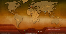
POPULATION
Amazing Real Time World Clock!

This clock courtesy of Poodwaddle.com · See real time population, death, illness, energy use, environmental statistics, food production and much more!
A Quick Trip to 7Billion
After completing the World of 7Billion PRE-TEST pop quiz. Click on the Quick Trip to 7Billion link above to explore the time line and wall chart.
PART 1: Exploring the Timeline
Each event on the timeline is labeled with topic symbol. (Communications, Environment, Food and Agriculutre, Health, Industry/Transportation, Population, Social Justice, or Women's Roles). Events in each of these topics have had direct and indirect impacts on our population over the years.
1. Choose one other topic (from the Topic Key) in addition to Environment. read through each event that is labeled with Environment and the other topic you chose.
2. Complete the graphic organizer, "Topic Essay" (provided in class) to structure the essay you will prepare in class. Answer each question on the worksheets for both (your choice and Environment) topics. It is suggested that you conduct additional research.
3. Some helpful resources are below:
"Research Resources" listed under the Student Video Contest tab, found at Worldof7Billion.org
www.fao.org
www.who.int
http://ngm.national geographic.com/7-billion
PART 1: Exploring the Timeline
- Read the timeline and work through the questions provided.
- Correct any misconceptions on the PRE_TEST pop quiz.
Each event on the timeline is labeled with topic symbol. (Communications, Environment, Food and Agriculutre, Health, Industry/Transportation, Population, Social Justice, or Women's Roles). Events in each of these topics have had direct and indirect impacts on our population over the years.
1. Choose one other topic (from the Topic Key) in addition to Environment. read through each event that is labeled with Environment and the other topic you chose.
2. Complete the graphic organizer, "Topic Essay" (provided in class) to structure the essay you will prepare in class. Answer each question on the worksheets for both (your choice and Environment) topics. It is suggested that you conduct additional research.
3. Some helpful resources are below:
"Research Resources" listed under the Student Video Contest tab, found at Worldof7Billion.org
www.fao.org
www.who.int
http://ngm.national geographic.com/7-billion
Intro to Earth
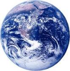
Click on the Earth to locate and define the branches of Earth Science.
Geology
Oceanography
Meterology
Astronomyhttp://www.weebly.com/weebly/mainhttp://www.weebly.com/weebly/main.php#.php#
Earth's Spheres
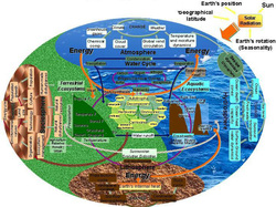
Click on the image to the left to investigate the interactions of Earth's spheres. Answer all the questions on your handout.
Hydrosphere
Where is Earth's Water?
USGS Water Cycle a Short Summary
Click here to access the practice problems for latitude and longitude.
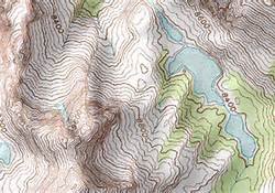
TOPOGRAPHIC MAPS
Click on the image of the topographic map to access the Student Exploration: Reading Topographic Maps Gizmo. Complete all activities and questions. You will need to enter the class code provided AND enroll in the class before you begin.
Click on the image of the topographic map to access the Student Exploration: Reading Topographic Maps Gizmo. Complete all activities and questions. You will need to enter the class code provided AND enroll in the class before you begin.

REMOTE SENSING
Use the links to research and investigate more about Remote Sensing and LandSat Images.
Process of Remote Sensing
TYPES OF REMOTE SENSING
ELECTROMAGNETIC SPECTRUM VIDEO TOUR
LANDSAT MORE THAN A PRETTY PICTURE POWERPOINT SLIDES
READING SATELLITE IMAGES
Use the following 2 websites to investigate how to interpret different satellite images.
Earth Observatory
Geospatial Data Service Center
FOOTPRINT CALCULATOR

How much land area does it take to support your lifestyle? Click the picture to the left. Take this quiz to find out your Ecological Footprint, discover your biggest areas of resource consumption, and learn what you can do to tread more lightly on the earth.
1.Take this quiz to find out your Ecological Footprint
2. Go to the Ecological Footprint blog.
3. Post your results of your Ecological Footprint Scores.
(Include # of Earth’s, breakdown, global acres, and tons of CO2. )
Can you reduce your Ecological Footprint?
4.Discover your biggest areas of resource consumption by returning to your quiz and click on EDIT YOUR FOOTPRINT.
5.Go to the Ecological Footprint blog.
6. Describe the actions you could take to reduce your ecological footprint and your new Ecological Footprint Scores.
GENERATING HEAT
Part 2: The Growth of Carbon Emitters
In this computer lab activity you will graph the growth in world population and carbon dioxide emissions over time. Follow the directions on your handout to create the graph in an Microsoft Excel spreadsheet and answer the questions. PRINT your graph as a full sheet (DON'T FORGET YOUR NAME!)
In this computer lab activity you will graph the growth in world population and carbon dioxide emissions over time. Follow the directions on your handout to create the graph in an Microsoft Excel spreadsheet and answer the questions. PRINT your graph as a full sheet (DON'T FORGET YOUR NAME!)
Nova: History Of the Universe
Click on the link above to explore the history of the Universe.
COMPLETE BIG BANG TIMELINE & STEPS OF NEBULAR HYPOTHESIS
ORIGINS: BACK TO THE BEGINNING
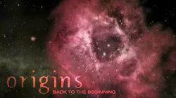
Click on the picture to view the video. Answer the questions on your hand out. These are due by the end of the period.
Origins: Earth is Born
Click on the image belwto view the video and compete the Response Sheet: Origins: Earth is Born
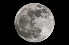
Formation of the Moon: Five Wild Theories
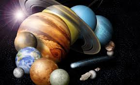
PLANET INVESTIGATION
Use the links below to complete the requested information on the "What's your favorite planet" chart.
1.What's Your Favorite Planet
2. Tour the Solar System
3. NASA: Solar System Explorations
Stellar Evolution
Pre-reading vocabulary: protostar, life cycle, main sequence star, red giant, white dwarf, black dwarf, supernova, neutron star, pulsar, black hole, fusion, element, isotope, X-ray, gamma-ray. Imagine the Universe! Dictionary. Available:
http://imagine.gsfc.nasa.gov/docs/dictionary.html#gravity
Read the technical document and examine the accompanying images for "Life Cycles of Stars" at The Life Cycles of Stars: How Supernovae Are Formed, Available:
http://imagine.gsfc.nasa.gov/docs/teachers/lessons/xray_spectra/background-lifecycles.html ).
Stars-Try This! Identify the stage of stellar evolution
Galaxies Galore
|

|

|
CONSTELLATIONS
|
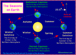
The Seasons and Axis Tilt
From the Enchanted Learning website. Overview of vocabulary and mechanisms related to Earth's seasons. Click on the image to the left. This closely follows the powerpoint and notes we discussed in class.
From the Enchanted Learning website. Overview of vocabulary and mechanisms related to Earth's seasons. Click on the image to the left. This closely follows the powerpoint and notes we discussed in class.
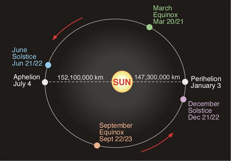
Aphelion and Perihelion
EARTH IN SPACE
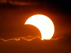
ECLIPSES
Click on the solar eclipse picture to access the ECLIPSE ANIMATION. Use the animation to investigate and to respond to the questions on your handout.
Click on the solar eclipse picture to access the ECLIPSE ANIMATION. Use the animation to investigate and to respond to the questions on your handout.
EARTH IN SPACE QUIZ
After you have completed all 3 parts of the Earth in Space activities. Take THE QUIZ here. Show your score to your instructor before closing the browser. You may want to print the quiz when complete.
THE SUN
Nuclear Reactions
BIOMES
Click on the link above, watch the video and complete the BIOME DISCUSSION QUESTIONS.
RELATIVE DATING PRACTICAL LAB QUIZ
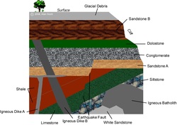
Click on the image to the left and follow the directions to complete the relative sequence of geologic events.
HINT: # 20, 18, 13, 8, and 2 are erosion.
HINT: # 20, 18, 13, 8, and 2 are erosion.
RADIOACTIVE DATING

Click on the image to open the radioactive lab simulation. Follow all directions on your handout. Record your answers on your handout. This is to be complete in one class period. ANY work not complete should be done in Smartbreakfast!
Periodic Table
Follow class room directions.
IONIC BONDING

This interactive activity from ChemThink discusses ionic bonding—a type of chemical bond formed between two ions with opposite charges. Investigate how the transfer of electrons between atoms creates ions and how the mutual attraction of these charged particles forms ionic bonds. Also learn about trends in the periodic table of elements, and explore how the structure of an ionic compound relates to its formula.
COVALENT BONDING

This interactive activity from ChemThink describes covalent bonding—a type of chemical bond that involves the sharing of electrons. Investigate the attractive and repulsive forces that act on atomic particles and how the sharing of electrons can keep atoms together. See how two hydrogen atoms interact with each other to create a covalent bond. Learn about trends in the periodic table and how electrostatic potential energy determines the bond length. Also, learn about naming conventions for covalent compounds.
Follow the instructions closely as you move through this activity! There are some screens where you have to do something before you can move onto the following screen.
Follow the instructions closely as you move through this activity! There are some screens where you have to do something before you can move onto the following screen.
STRUCTURES OF METALS

This interactive activity from the NOVA Web site describes the crystalline structure of metal and uses animations to illustrate the molecular changes that occur when a metallic substance is bent, heated, or otherwise changed by external forces.
LEWIS DOT DIAGRAMS
Click here to test your knowledge of Lewis Dot Diagrams.
THE VIRTUAL CAVE

Download the document below and follow the directions to complete your Virtual Cave Tour Field Trip. Click on the image to locate the virtual cave.
Virtual Cave Tour Assignment
Virtual Cave Tour Assignment
MINERAL IDENTIFICATION LAB

Click on the image to the left to go to the Virtual Mineral Identification Lab. Follow the directions to complete the lab. Record your results in the data table and answer the journal questions.
LITHOSPHERE-ROCKS INTERACTIVE

Click on the image to the left to access ROCKS-Interactive. Follow the website through all of the topics information and complete each activity. Fill in your hand out where applicable.
MASS MOVEMENT AND WIND

With your group you will create a movie on the topics of Mass Movement and Wind using WINDOWS MOVIE MAKER.
Step 1: Check your work. After showing your groups completed work to your instructor click here to view the key for 5.3 Click here to view the key for 7.3.
Step 2: Plan. With your group you will create a movie that contains the information from the notes you collected about mass movements and wind. Your group may choose to split the two projects into 2 movies (1 for each topic) or just 1 movie with 2 topics. EVERYONE in your group must be an active participant. Plan and submit to your teacher before beginning. See the RUBRIC for details on how you will be graded.
Step 3: Open Windows Movie Maker by clicking on START in lower left of your screen under All Programs click Windows Movie Maker. Familiarize yourself with the tools. Your movie should include narration and pictures that help describe your topic details. Your movie may also include music if available. HINT all files (music, pictures etc.) must be saved in the same location as your movie file in your U drive.
THIS IS DUE NO LATER THAN THURSDAY AT THE BEGINNING OF CLASS! NO EXCEPTIONS. IF SOMEONE IS ABSENT FROM Y0UR GROUP YOU WILL HAVE TO TAKE UP THEIR SLACK!
WEATHERING
Use each of the links below to access each investigation module. Create word document and answer all of the questions posed in the module. Label each module with a heading. Include all questions. Print and place in your notes section of your binder. We will review and discuss your answers as a class.
WEATHERING INFO LINKS
Continental Divide: The Breakup of Pangea
Click on the link above to access the interactive module to answer your discussions questions on the handout provided.
CONTINENTAL DRIFT VIDEO CLIPS
Introduction to Continental Drift
The Scientist Behind the Theory
Plate Tectonics: Further Evidence
Introduction to Continental Drift
The Scientist Behind the Theory
Plate Tectonics: Further Evidence
VIRTUAL EARTHQUAKE LAB

_
EPICENTER LOCATION AND MAGNITUDE DETERMINATION
In this activity, you will determine the location of an earthquake's epicenter and estimate its Richter magnitude. You will be working with seismograms, which are the records of earthquake waves.Click on the image to the left to begin.
EPICENTER LOCATION AND MAGNITUDE DETERMINATION
In this activity, you will determine the location of an earthquake's epicenter and estimate its Richter magnitude. You will be working with seismograms, which are the records of earthquake waves.Click on the image to the left to begin.
Earthquake Main Ideas
Virtual Earthquake Lab Alternative
Click on the link here to enter the virtual earthquake lab. Upon completion of this activity you will be given the opportunity to receive a personalized Certificate as a "Virtual Seismologist."
In order to get this certificate, you must make careful measurements throughout the activity. Follow the options to email this certificate to yourself, print it and submit to your instruction. This will be a lab grade.
GEOLOGIC TIME SCALE
Earth Revealed: Geologic Time: Video click here
HELPFUL WEBSITES
BEGIN HERE!
REMINDER: DOCUMENT ALL SOURCES FOR ALL PROJECTS!!
1. Follow links for animations showing land areas through time and information about the different geologic periods
http://www.ucmp.berkeley.edu/geology/tectonics.html
2. Paleo-map Project – History and Climate in each of the Geologic Periods
http://www.scotese.com/earth.htm
3. How the Different Geologic Periods Got Their Names
http://pubs.usgs.gov/gip/geotime/divisions.html
4. The Paleozoic Era
http://pubs.usgs.gov/gip/geotime/divisions.html
5. The Mesozoic Era
http://www.bobainsworth.com/fossil/mesozoic.htm
6. The Cenozoic Era
http://www.bobainsworth.com/fossil/cenozoic.htm
7. EXTINCTION OF DINOS - CENOZOIC ERA AND ADVENT OF MAMMALS AND HUMANS
http://darwin.bio.uci.edu/~sustain/bio65/lec02/b65lec02.htm#MAMMALS
8. Printable Geologic Time Scale
9. Geological Time Periods: The table below is a very simple Geological Time Line.
http://earthsci.org/fossils/youngp/periods/periods.html
10. CENOZOIC ANIMALS
http://users.telenet.be/educypedia/education/beastsafterdinosaur.htm
11. EXTINCTION OF DINOS - CENOZOIC ERA AND ADVENT OF MAMMALS AND HUMANS
http://darwin.bio.uci.edu/~sustain/bio65/lec02/b65lec02.htm#MAMMALS
12. A Short Look at Earth History
http://www.uwgb.edu/dutchs/EarthSC102Notes/102OverviewEarthHistory.htm
13. Prehistoric Time Line
http://science.nationalgeographic.com/science/prehistoric-world/prehistoric-time-line/
14. An interactive Geologic Time Scale
http://www.enchantedlearning.com/subjects/Geologictime.html
15. Victoria evolves The exhibition brings the story of Victoria’s evolution to life through animation, animatronics, models, fossils and multimedia interactives
http://museumvictoria.com.au/prehistoric/what/geotime.html
REMOTE SENSING

Use the websites below to complete your notes and answer the discussion questions.
Remote Sensing
What is it? How is it useful?
Types of Satellites
Platforms for Remote Sensing
Complete the table.
Recognize many different earth features and landscapes.
Electromagnetic Spectrum
Diagram the spectrum. Include types of energy and size.
Diagram and Explain REMOTE SENSING
Remote Sensing
What is it? How is it useful?
Types of Satellites
Platforms for Remote Sensing
Complete the table.
Recognize many different earth features and landscapes.
Electromagnetic Spectrum
Diagram the spectrum. Include types of energy and size.
Diagram and Explain REMOTE SENSING
TORNADOES AND LA NINA
Click here to access the Anticipation Guide on Tornado Formation and La Nina.
Click on the links below to view the videos.
TORNADO FORMATION
TORNADOES AND LA NINA
Click on the links below to view the videos.
TORNADO FORMATION
TORNADOES AND LA NINA
WEATHER MAP ACTIVITIES
Click on the link here to acess the Southeast Regional Climate Center (SERCC) Weather Map Activity. Complete all the activities and fill in your responses on the handout.
Click on the link here to complete the Meteorologist Weather Prediction Virtual Lab. Read all information and instructions as directed. Fill in the journal question.
Click on the link here to complete the Meteorologist Weather Prediction Virtual Lab. Read all information and instructions as directed. Fill in the journal question.
Regions of North Carolina
Click on the power point above and complete your notes. Use your notes to answer the self check questions.
NC NATURAL HISTORY
Click on the link above to complete your chart on the Natural History of North Carolina.
